When I moved to Mid-City at the start of 2006, and now when I return to visit my brother, I’m sometimes asked with reserved uncertainty where I grew up or which high school I attended. New Orleanians can tell if you’re from out of town. But because my father’s family is from NOLA and I took my fair share of family-oriented trips down there as a kid (and not-so-family-oriented trips as an adolescent), I don’t totally stand out as being non-native.
Telling them that I grew up in Alexandria seems to explain everything. “Oh, you’re from Northern Louisiana. That makes sense.” As casually as possible, I remind them that not everything above I-10 is in the northern part of the state.
“Alexandria’s in Central Louisiana, not even ninety miles north of Lafayette.” It’s true; citizens in Rapides and other Central Louisianan parishes are proud to be from a distinct area of the state, and will readily defend CenLa as a unique place to live. That isn’t to say that we haven’t been ready to work with both Northern and Southern Louisiana on a range of social and political issues. Moreover, I firmly believe that Central and Northern Louisiana, as largely unprepared as we were, did all that was possible to assist our fellow Louisianans when natural disasters and the failure of federal levees scattered the residents of Southern Louisiana from their homes and communities.
A photo of England Airpark, from MSNBC in 2005:
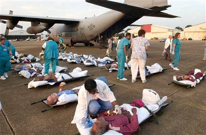
Darlene Humphrey, foreground center, a nurse with the Alexandria Veterans Affairs Medical Center, tends to one of the patients evacuated in the aftermath of Hurricane Katrina from a hospital in New Orleans by the Missouri Air National Guard to Alexandria, La., on Sept. 1.
If Hurricanes Katrina and Rita showed us anything, they showed that our geography in the heart of Louisiana—though just outside of Southern Louisiana—pinpoints the essential role that only we can provide to the rest of the state.
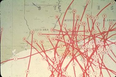
This map charts the paths hurricanes have taken in Louisiana between 1831 and 1975. It is from the Meteorology and Hurricanes section of America’s Wetland Resources, a valuable website with lots of useful information on coastal ecology. Though Alexandria is not completely spared from the damage that is wrought from the heavy thunderstorms a hurricane brings, it is the southernmost city in Louisiana that is outside the hurricane risk zone.
In the opinions of the editors of this blog, Alexandria is currently experiencing growing pains as it determines its place in 21st Century Louisiana. Two years after the catastrophic storms that have become a defining moment for this great state, Louisiana is still reeling from the impacts of those storms. We were reeling then from what was already not a perfect place to live. We have not yet recovered economically or environmentally; we have not recovered in terms of health, education, politics, or social justice. We have not yet recovered from the realization that the destiny of Louisiana is and always has been in our hands alone.
When I went back to Terranova’s in Mid-City last month after being away for a year, my grocer still remembered me. She let me owe her on being a couple of dollars short. “Don’t worry about it, baby. One hand washes the other,” she said in the inimitable Orleans Parish accent that even my father hasn’t completely lost.
One hand washes the other. Now is the time for Alexandria—all of CenLa really—to recognize that it owes it to Southern Louisiana to remake itself as an organizational and technological leader for state emergency preparedness. We must all strive tirelessly, hand in hand, for the future of the entire State of Louisiana.

Leave a comment